Point Impossible to Jan Juc Master Plan
Point Impossible to Jan Juc Master Plan
Torquay and Jan Juc Foreshore Reserves
The 11.5 kilometres of coastal foreshore between Point Impossible and Jan Juc is Crown land managed by the Great Ocean Road Coast Committee (GORCC). This stretch of coast has evolved to become a popular destination for residents, visitors and tourists.
For thousands of generations, the Wadawurrung people cared for and protected these lands and waters. We pay our respects to their Ancestors and Elders – past, present and emerging, and commit to walking alongside the Wadawurrung when planning for and managing the foreshore reserve.
In 1998, the Torquay Public Reserves Committee of Management (now GORCC) commissioned a master plan and management plan for the foreshore between Point Impossible and the three-tier car park in Jan Juc. The 1998 plan focused on managing vehicle and pedestrian access by defining, formalising and constructing several car parks at Point Danger, Cosy Corner, Fishermans Beach and the Nudist Beach. The foreshore reserves have considerably evolved since this time, now providing:
- Important marine, intertidal, coastal dune and woodland habitat for local, regional and internationally significant flora and fauna.
- Extensive areas of public open space, providing a strong sense of place and enabling opportunities for social interaction and recreation.
- Important coastal infrastructure to facilitate our enjoyment of the coast including beach access points, playgrounds, picnic tables and BBQs, car parks, amenity blocks, boardwalks.
- Highly valued community buildings and facilities including a boat ramp, sailing club, fishing club, and two Surf Life Saving Clubs.
- Activities including surf schools, events, markets and festivals, and modern and desirable services including kiosks, mobile food vendors, restaurants and cafes.
Master plan project
Master plans provide us and our community with a dynamic blueprint for a 10-15 year period. They set the vision and high-level actions to guide future use and development of an area and assist in long-term planning to ensure adequate resourcing of the coastal and marine environment.
This draft master plan has been informed by community and stakeholder consultation conducted over summer 2019. The consultation identified several themes and proposed improvements to be considered in developing the draft master plan.
What we heard
Community and stakeholder consultation on the initial issues and opportunities identified five priorities:
- Protect environmental values
- Address the pressures of development, population and visitation growth
- Address conflicts in beach use and access
- Manage and adapt to risks of climate change, including erosion and inundation
- Improve circulation path networks, and all abilities access, to and around the foreshore.
Key themes, implications and responses
Climate change
Our community considers climate change a key challenge, with sea-level rise and beach and cliff erosion being major concerns. They would like to address climate change by improving and increasing natural assets (dune systems and shade provided by trees) and implementing monitoring to manage and adapt to erosion and inundation.
The impacts of climate change, including shoreline recession, erosion and water security are recognised as one of our key challenges to managing the coastal and marine environment.
For example, if a section of the Surf Coast Walk is at risk from shoreline recession and cliff instability, do we decommission an important built asset which facilitates coastal enjoyment and stewardship, or realign it within an area of natural dune ecosystem?
We are committed to planning for, and responding to, climate change over the short, medium and long term by allowing natural processes such as erosion and shoreline recession to continue within natural areas including Whites Beach and Jan Juc; minimising built infrastructure within areas vulnerable to climate change such as cliff edges, dunes and waterways; establishing shade trees to create habitable landscapes; and ensuring existing facilities are upgraded using relevant climate change data and modelling and incorporating best practice sustainable design.
Increased use and visitation
Our community enjoys accessing long stretches of undeveloped beach that are less populated than in other coastal areas. They have concerns that an increase in development such as car parking will encourage more people, with some suggesting limiting parking and implementing population controls to manage increased visitation. Our community would also like us to proactively manage anti-social behaviour associated with littering, dogs and use of the Nudist Beach.
Visitation to the Great Ocean Road region is forecast to reach 8.6 million visitors by 2026-27. The population of our region (Surf Coast) is currently over 315,000 and is projected to increase to 500,000 by 2050. As resident and visitor numbers increase and diversify, so too does the way we use our coast.
As a Crown land manager, we must strike a balance between maintaining healthy and functioning ecosystems with the economic and social benefits of coastal use and development. Our highest priority is protecting and enhancing our natural environment and cultural heritage. Any opportunities for quality visitor and tourist development must balance safety, future use and the long-term health and values of the coast.
While we are unable to influence the number and diversification of marine and coastal users, we are committed to understanding current and future demands to proactively manage conflict. We will continue to facilitate equitable access to, and enjoyment of, our coast by focusing new infrastructure and facilities within modified areas and managing natural areas for biodiversity; monitoring the use of facilities and infrastructure to make informed decisions on when and how to upgrade; providing additional services and facilities for Life Saving Victoria; and encouraging our community to reduce their reliance on cars rather than expanding parking areas.
Built facilities and infrastructure
Our community conveyed the need for infrastructure to keep pace with demand, including showers and toilets at all major beaches. Better all abilities access to and around the foreshore, maintenance and watering of grassed areas, and signage to increase education and compliance were all commonly requested.
Our ageing-built infrastructure, established during a time without consideration of climate change, is now under growing pressure as our population and visitation increases. The impacts of climate change, such as major storm events, mean significant long-term funding is required to maintain our existing built infrastructure. Existing and new assets must be maintained, upgraded and replaced over time. A key challenge for all Crown land managers is determining who should pay for this ongoing work and how.
Considering this key challenge, we are committed to enabling people with different mobilities to access and use our coast; redeveloping our playgrounds with natural materials, integrated artwork and nature-based play to educate future generations and develop stewardship; and monitoring low-use assets such as lookouts and amenity blocks to either decommission, relocate or maintain and upgrade.
A new authority
The Great Ocean Road Coast and Parks Authority (GORCPA), is due to commence in 2020, replacing GORCC and other land managers along the Great Ocean Road. The development and implementation of the final master plan are subject to consultation outcomes, agency approval and funding. Each master plan is informed by community and stakeholder feedback and is approved by the Department of Environment, Land, Water and Planning. GORCC will present and advocate the final master plan to GORCPA for adoption.
Have your say
Feedback was open on the draft master plan from Thursday 9 January until Sunday 16 February 2020.
The following consultation sessions were held during this time:
- Friday 24 January, 10am-12noon: Torquay Front Beach – opposite Growlers between Anderson and Price Streets
- Saturday 15 February, 2-4pm: Torquay Angling Club, Fishermans Beach.
Next steps
Feedback received during the consultation period will help inform the development and design of the final master plan.
Following consultation in January-February 2020, the key next steps are:
- Compile community and stakeholder feedback
- Develop the final master plan
- Finalise master plan and obtain required statutory approvals
- Release final approved master plan
- Commence implementation of actions in the master plan.
Project documentation
Projects
Point Impossible to Jan Juc Master Plan
Taylor Park Master Plan
Background
Taylor Park is situated in the heart of Torquay and provides the main public open space for the town centre other than the beach and foreshore. The park is Crown land managed by the Great Ocean Road Coast Committee (GORCC) under the Crown Land (Reserves) Act 1978.
The draft master plan has been informed by community and stakeholder consultation conducted over summer 2018/19. The key themes highlighted included:
- retaining the natural bushland character of the park
- protection from development
- additional and upgraded facilities including a grassed area
- environmental and heritage educational signage.
The Wadawurrung name for Taylor Park is ‘djirnap’ – the place of the white cockatoo.
The Torquay Bowls Club site within Taylor Park is leased from GORCC under a 21-year Crown land lease. GORCC acknowledge the Bowls Club’s desire for lease expansion however consultation has identified strong mixed views. GORCC supports the Bowls Club in its current capacity and use. Without further consultation and investigation GORCC cannot support or commit to an extension to the lease area. GORCC will continue to work closely with the Bowls Club.
Priority works have been submitted for consideration in GORCC’s draft 2019/20 budget.
A new authority, Great Ocean Road Coast and Parks Authority, is due to commence in December 2020, replacing GORCC and other land managers along the Great Ocean Road. Great Ocean Road Coast and Parks Authority will become the Crown land manager and therefore be responsible for the management of the park, and implementation of the plan moving forward. A clear delivery plan for staged works over the life of the plan will be presented to Great Ocean Road Coast and Parks Authority.
Community consultation
During April and May 2019, GORCC gathered community and stakeholder feedback on the Taylor Park Draft Master Plan.
Consultation attendance and feedback was strong, with over 100 individuals and groups contributing.
Feedback was sought through multiple channels, including two community consultation sessions, an online survey, meetings with community and agency groups, individual submissions, and significant digital and media promotion.
What we heard
The results highlighted some key themes:
Importance of natural environment and wildlife
Respondents support gradual replacement of existing exotic vegetation with local indigenous trees and shrubs to attract wildlife. They value the natural bushland character of the park and support the landscaping of the pond area. They would also like to see increased tree maintenance for safety reasons.
Signage
An information board at key entry points that includes a map of the park, information about the history of the gates, the native flora and fauna, and the cultural heritage of the park was recommended.
Facilities
Respondents would like to see the following assets in the park improved:
- Paths: improve paths and use a medium on them that is more suitable during wet weather
- Lighting: additional lighting for safety, and improved lines of sight were recommended
- Picnic areas: respondents supported increasing the number of picnic facilities along Zeally Bay Road and recommend this be changed to a short term priority.
Integration with town and foreshore
Respondents would like to see improved integration of Taylor Park with the town centre and the foreshore. A suggestion was to create entrances, so the park seamlessly connects with both precincts.
This feedback will help inform the development and design of the final master plan.
Next steps
Following consultation over Easter 2019, the key next steps are:
- Finalise master plan and obtain required statutory approvals
- Release final approved master plan
- Commence implementation.
Project documentation
Projects
Point Impossible to Jan Juc Master Plan
Steps access stair replacement – Jan Juc
Update
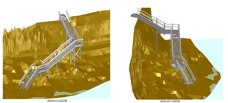
Works on a replacement of the stairs at popular surf access point Steps and Boobs in Jan Juc are now complete.
Works to replace the beach access stairs, upper tier lookouts and boardwalk sections commenced in April and were completed in early June.
The second stage of the project included the demolition and construction of the lower section of stairs spanning the cliff base and boulders – this work commenced in May and was completed in early July 2019.
Background
Following a detailed design process, works commenced in April 2019 on a replacement of the stairs at popular surf access point Steps and Boobs. The works are a result of storm damage that occurred in June 2017.
The works are funded by the Great Ocean Road Coast Committee capital works program and a $60,000 grant from Department of Environment, Land, Water and Planning (DELWP) Coastal Environments Grant Program.
Works to replace the beach access stairs, upper tier lookouts and boardwalk sections commenced in April 2019 and were completed in early June 2019.
Ken Northwood, Chairman of the Great Ocean Road Coast Committee said the organisation had gone to public tender for the important upgrade with works targeted to begin as soon as possible, depending on weather and contractor availability.
“Steps is obviously an icon of the surf coast and leads the way to three popular surf breaks,” said Mr Northwood. “Current engineering advice is that while the current structure is safe to remain open, a replacement needs to be prioritised, which we have done.”
The replacement
The lower tier replacement stairs will be a non-slip fibre reinforced material in a similar alignment to the existing stairs. The non-slip surface is designed to be safer and to meet the predicted impacts of climate change. The upper tier stairs and lookout will be replaced in timber. Upgrades to drainage will also be completed to help prevent erosion.
The design and footings have been overseen by geotechnical and coastal engineering experts.
Project documentation
Projects
Point Impossible to Jan Juc Master Plan
Point Impossible Shorebird Protection Zone
The Great Ocean Road Coast Committee, with support from Surf Coast Shire, has established an on-lead dog zone at Point Impossible to protect wildlife including shorebirds from the impacts of dogs off leash.
The results of this project will be incorporated in the Great Ocean Road Coast Committee’s Coastal and Marine Management Plan review in 2018 – 2019.
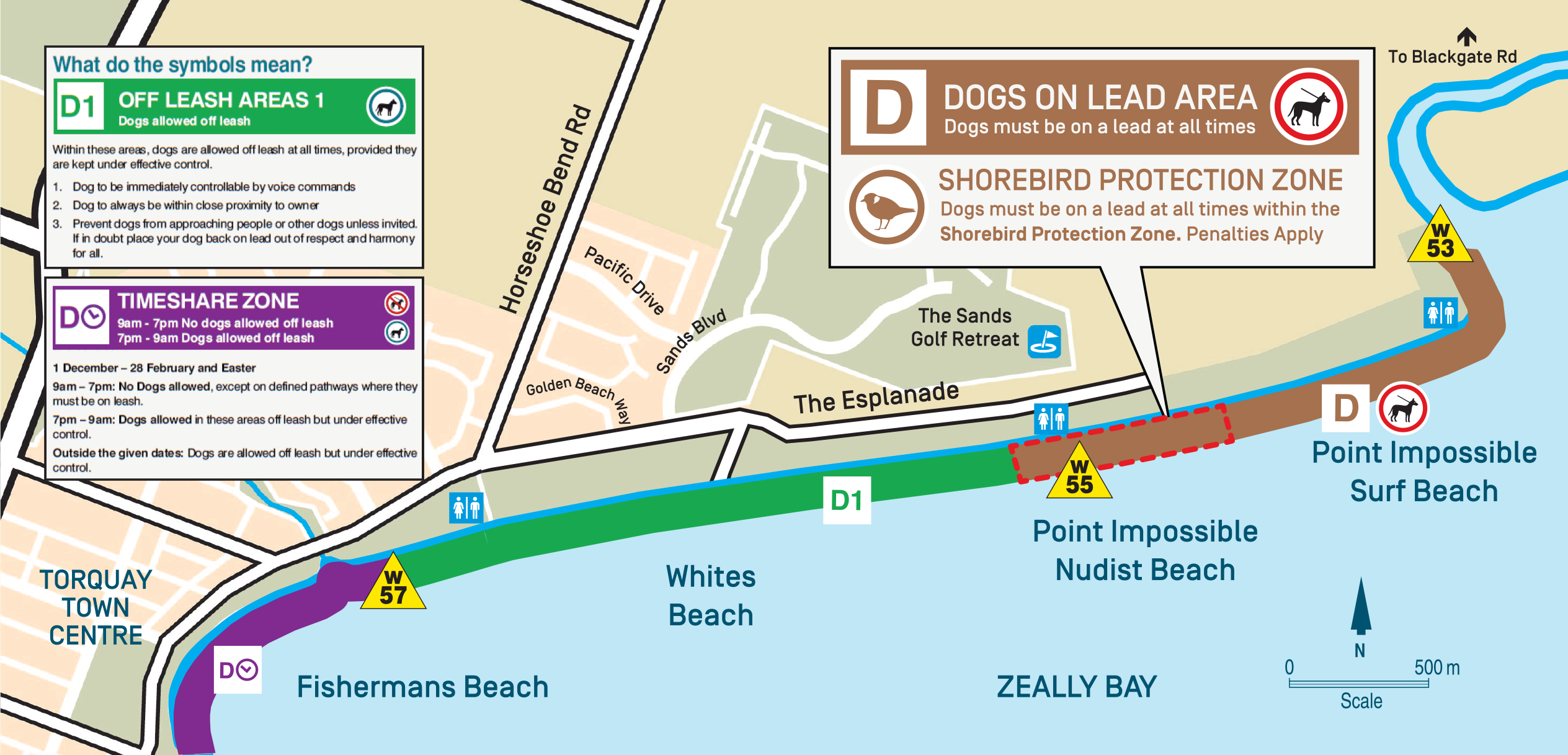
Coastal Reserves Manager Caleb Hurrell said the shore bird protection zone will focus on education and monitoring.
”We are asking all dog owners to keep their dogs on a lead between Thompsons Creek at Point Impossible and Point Impossible Nude Beach Carpark. We are also asking horse-riders, who are allowed to ride in this area with a permit, to stay well below the high tide mark. Existing D1 off lead areas will not be affected.”
“We all have to share our beaches with other beach users,” said Mr Hurrell. “Our intention is to collect information on the impacts of dogs and horses plus community attitudes, ahead of a formal review as part of the upcoming Coastal and Marine Management Plan.”
The Great Ocean Road Coast Committee welcomes feedback on the project and will monitor the impacts throughout the project.
“We will work with Surf Coast Shire compliance staff and volunteers from Birdlife Australia’s Friends of the Hooded Plover, CoastCare, Surf Coast and Torquay Coast Action to implement the program,” said Mr Hurrell. “Deakin University will be assisting with the project.”
The establishment of the on-lead area follows a community petition in 2017 calling for the protection of this critical shorebird site at Point Impossible that is important to migratory shorebirds from around the world as well as to our own nesting Hooded Plovers, a highly threatened species.
Dr Grainne Maguire said BirdLife Australia welcomed the on-lead zone at Point Impossible and encouraged community feedback.
“Unleashed dogs are a major threat to shorebirds that have flown tens of thousands of kilometres to feed on our shores, and to threatened Hooded Plover chicks. Off leash dogs have been identified as one of the leading causes of chick mortality. Only last year, a chick’s body was hidden in a rubbish bin at the nearby 13th beach after being mauled by an off-leash dog. Our research has also shown that Hooded Plovers are twice as likely to stay on the nest if a dog is on a lead while unleashed dogs cause parents to abandon the nest in over 50% of encounters. Co-existence is possible.”
Download a printable copy of the Point Impossible Shorebird Protection Zone brochure.
Q & A
Shorebird Protection Zone Q&A
Q: After 20 years of no controls why change now?
A: The aim of the protection zone is to continue to reduce the impact of dogs, horses and humans on shorebird habitat whilst educating the community on shorebird conservation. Increasing visitor numbers have created great pressure on native animals and plants. We are actively managing this to improve the poor survival rates of shorebirds in particular. We are seeking to strike a balance between visitor behaviour and conservation efforts.
Q: My dog is not aggressive why should I keep it on a leash?
A: Regardless of individual dogs their uncontrolled presence disturbs sensitive nesting areas. Approaching birds on nests causes the nest to be abandoned in 50% of cases.
Q: Why should I care about birds?
A: We are asking people to keep their dogs on leads in this area. It’s about balancing the protection of native animals and plants whilst allowing for human activity to continue along the beach.
Q: What’s changed for horses?
A: Same regulation as before: horses are required to stay below the high-tide line. We are adding the requirement to steer clear of the breeding exclusion area.
Q: Where else can I take my dog?
Surf Coast Shire have a map and list of regulations. The map is currently being updated to reflect the new zone at Point Impossible.
Projects
Point Impossible to Jan Juc Master Plan
Torquay Bowls Club redevelopment | 2014
Project completed | 2014
The Torquay Bowls Club redevelopment was officially opened in March 2014.
Member for South Barwon Andrew Katos officially opened the Torquay Bowls Club (TBC) on 7 March 2014, marking the completion of a $1.75 million redevelopment and the delivery of new community hub for the region.
The project has provided new facilities for the TBC’s growing membership and a home for community organisations, including the Torquay RSL sub-branch.
The project was supported by the Great Ocean ROad Coast, the land manager, as the site is situated on Crown land. Great Ocean Road Coast auspiced the grant on behalf of the TBC, who worked closely with the Torquay RSL Sub – branch. The project is was overseen by a ‘redevelopment team’ comprising the TBC, Regional Development Victoria, Great Ocean Road Coast and Surf Coast Shire representatives.
The planning process was funded by a State Government grant of $1.5 million which was announced by the Member for South Barwon, Andrew Katos. This grant was supported by more than $200,000 contributed by the TBC itself and more than $25,000 of in kind support from Great Ocean Road Coast.
The plan was developed by Insite Architects and construction was undertaken by Lyons Construction.
Projects
Point Impossible to Jan Juc Master Plan
Whites Beach Amenities Block | 2015
Project completed | 2015
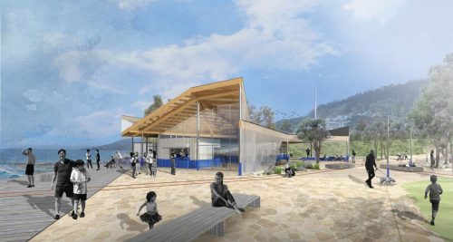
The Great Ocean Road Coast Committee has constructed a new public toilet facility on the foreshore at Whites Beach in the vicinity of The Esplanade and Sands Boulevard, Torquay.
This $90,000 project, which saw the construction of an amenities block in this popular location, was fully funded by Great Ocean Road Coast and forms part of the implementation of the Torquay Foreshore Master Plan.
The Whites Beach area is a popular destination and visitation is expected to increase following recent upgrades to the adjacent Surf Coast Walk and projected population growth.
The facility incorporates a one unit system with disabled access. It has a user-friendly and sensitive design consistent with its high visibility and use.
Projects
Point Impossible to Jan Juc Master Plan
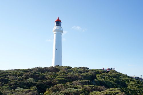
Rocky Point Lookout | 2015
GORCC has replaced the Rocky Point Lookout thanks to a $220,000 donation from the RACV Torquay Resort.
The existing, ageing lookout had reached the end of its service life and required replacement. The new structure offers enhanced accessibility and a richer, higher quality visitor experience.
A feature of the new lookout is its organic shape which is inspired by the waves that wrap around the Point. The site features breathtaking views over several of the region’s favourite surf breaks.
The eastern platform overlooks Torquay Point and the surf beach and standing on the western platform, visitors will be able to see along the coast towards Bells.
Interpretive materials have been installed at the lookout to explain how the rock layers of the ‘Bird Rock Dome’ create the perfectly shelving reefs that shape reef breaks from Bird Rock to Winkipop.
The path from Spring Creek to the lookout has also be redeveloped to improve access and enable people with limited mobility to enjoy the new facility.
Projects
Point Impossible to Jan Juc Master Plan
Optional dress car park redesign | 2015
Project completed | 2015
The optional dress car park in Torquay has undergone a makeover.
Works to redesign this car park were completed by peak season 14/15. The site receives consistently high use through the warmer periods, however it was formerly poorly drained, with less than ideal traffic layout and aesthetic.
The works saw no change to the number of parking spots, but a more functional configuration of the site.
Works included:
- Installation of vehicle wheel stops
- Installation of barriers to contain vehicles within the existing gravel area
- Grading to improve drainage
- Provision of drainage points
Works cost around $47,000 and were fully funded by the Great Ocean Road Coast Committee. No vegetation was removed and further revegetation works will be undertaken later in 2015.
Project documentation
Concept Plan | 2004
Projects
Point Impossible to Jan Juc Master Plan
Caravan and camping park rule review | 2015
Review completed | 2015
A comprehensive review of existing rules for GORCC’s Lorne and Torquay Foreshore Caravan Parks has now been completed.
This process has included three parallel streams of work:
- Development of the new minimum standards (specifically designed to replace the current ’30 year van rule’ applying to TMP and Seasonal Permit holders)
- A wider rule review considering all caravan park rules.
- Review of permit terms and conditions in order to update them and ensure they are consistent with the above documents.
Following extensive consultation with both Seasonal Permit and TMP holders, including ongoing discussions with the Torquay Concerned Campers Committee, all feedback received has been considered in the development of a final version of each document.
These three documents have now been approved by the Committee.
Final Documentation
Park Rules | May 2015
TMP and Seasonal site minimum standards
Consultation Reports
Camper Forum (Torquay) Report | January 2014
Camper Forums (Torquay & Lorne) Report | Easter 2014
Projects
Point Impossible to Jan Juc Master Plan
Elephant Walk car park upgrade | 2015
Project completed | 2015
This popular precinct has been upgraded to improve pedestrian safety, increase grassy open space, protect existing trees, increase indigenous vegetation and provide disabled parking.
The Elephant Walk car park at Yellow Bluff provides public parking for the Torquay Play Park and picnic areas along the foreshore. The redevelopment of the toilet block and car park were undertaken in accordance with the principles and recommendations of the Torquay Foreshore Master Plan.
In addition to the replacement of the old toilet block in 2014, the 2015 works included:
- Improving pedestrian safety by increasing the car park and road set back from the edge of the playground.
- Increasing available grass open space and picnic areas overlooking the foreshore.
- Protection of the mature Cypress trees from vehicles and further root compaction.
- Establishment of additional indigenous planting and a stormwater treatment system.
- Provision of disabled parking at the new toilet block as per Australian Standards.