Point Impossible to Jan Juc Master Plan
Point Impossible to Jan Juc Master Plan
Torquay and Jan Juc Foreshore Reserves
The 11.5 kilometres of coastal foreshore between Point Impossible and Jan Juc is Crown land managed by the Great Ocean Road Coast Committee (GORCC). This stretch of coast has evolved to become a popular destination for residents, visitors and tourists.
For thousands of generations, the Wadawurrung people cared for and protected these lands and waters. We pay our respects to their Ancestors and Elders – past, present and emerging, and commit to walking alongside the Wadawurrung when planning for and managing the foreshore reserve.
In 1998, the Torquay Public Reserves Committee of Management (now GORCC) commissioned a master plan and management plan for the foreshore between Point Impossible and the three-tier car park in Jan Juc. The 1998 plan focused on managing vehicle and pedestrian access by defining, formalising and constructing several car parks at Point Danger, Cosy Corner, Fishermans Beach and the Nudist Beach. The foreshore reserves have considerably evolved since this time, now providing:
- Important marine, intertidal, coastal dune and woodland habitat for local, regional and internationally significant flora and fauna.
- Extensive areas of public open space, providing a strong sense of place and enabling opportunities for social interaction and recreation.
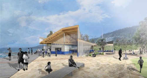
- Important coastal infrastructure to facilitate our enjoyment of the coast including beach access points, playgrounds, picnic tables and BBQs, car parks, amenity blocks, boardwalks.
- Highly valued community buildings and facilities including a boat ramp, sailing club, fishing club, and two Surf Life Saving Clubs.
- Activities including surf schools, events, markets and festivals, and modern and desirable services including kiosks, mobile food vendors, restaurants and cafes.
Master plan project
Master plans provide us and our community with a dynamic blueprint for a 10-15 year period. They set the vision and high-level actions to guide future use and development of an area and assist in long-term planning to ensure adequate resourcing of the coastal and marine environment.
This draft master plan has been informed by community and stakeholder consultation conducted over summer 2019. The consultation identified several themes and proposed improvements to be considered in developing the draft master plan.
What we heard
Community and stakeholder consultation on the initial issues and opportunities identified five priorities:
- Protect environmental values
- Address the pressures of development, population and visitation growth
- Address conflicts in beach use and access
- Manage and adapt to risks of climate change, including erosion and inundation
- Improve circulation path networks, and all abilities access, to and around the foreshore.
Key themes, implications and responses
Climate change
Our community considers climate change a key challenge, with sea-level rise and beach and cliff erosion being major concerns. They would like to address climate change by improving and increasing natural assets (dune systems and shade provided by trees) and implementing monitoring to manage and adapt to erosion and inundation.
The impacts of climate change, including shoreline recession, erosion and water security are recognised as one of our key challenges to managing the coastal and marine environment.
For example, if a section of the Surf Coast Walk is at risk from shoreline recession and cliff instability, do we decommission an important built asset which facilitates coastal enjoyment and stewardship, or realign it within an area of natural dune ecosystem?
We are committed to planning for, and responding to, climate change over the short, medium and long term by allowing natural processes such as erosion and shoreline recession to continue within natural areas including Whites Beach and Jan Juc; minimising built infrastructure within areas vulnerable to climate change such as cliff edges, dunes and waterways; establishing shade trees to create habitable landscapes; and ensuring existing facilities are upgraded using relevant climate change data and modelling and incorporating best practice sustainable design.
Increased use and visitation
Our community enjoys accessing long stretches of undeveloped beach that are less populated than in other coastal areas. They have concerns that an increase in development such as car parking will encourage more people, with some suggesting limiting parking and implementing population controls to manage increased visitation. Our community would also like us to proactively manage anti-social behaviour associated with littering, dogs and use of the Nudist Beach.
Visitation to the Great Ocean Road region is forecast to reach 8.6 million visitors by 2026-27. The population of our region (Surf Coast) is currently over 315,000 and is projected to increase to 500,000 by 2050. As resident and visitor numbers increase and diversify, so too does the way we use our coast.
As a Crown land manager, we must strike a balance between maintaining healthy and functioning ecosystems with the economic and social benefits of coastal use and development. Our highest priority is protecting and enhancing our natural environment and cultural heritage. Any opportunities for quality visitor and tourist development must balance safety, future use and the long-term health and values of the coast.
While we are unable to influence the number and diversification of marine and coastal users, we are committed to understanding current and future demands to proactively manage conflict. We will continue to facilitate equitable access to, and enjoyment of, our coast by focusing new infrastructure and facilities within modified areas and managing natural areas for biodiversity; monitoring the use of facilities and infrastructure to make informed decisions on when and how to upgrade; providing additional services and facilities for Life Saving Victoria; and encouraging our community to reduce their reliance on cars rather than expanding parking areas.
Built facilities and infrastructure
Our community conveyed the need for infrastructure to keep pace with demand, including showers and toilets at all major beaches. Better all abilities access to and around the foreshore, maintenance and watering of grassed areas, and signage to increase education and compliance were all commonly requested.
Our ageing-built infrastructure, established during a time without consideration of climate change, is now under growing pressure as our population and visitation increases. The impacts of climate change, such as major storm events, mean significant long-term funding is required to maintain our existing built infrastructure. Existing and new assets must be maintained, upgraded and replaced over time. A key challenge for all Crown land managers is determining who should pay for this ongoing work and how.
Considering this key challenge, we are committed to enabling people with different mobilities to access and use our coast; redeveloping our playgrounds with natural materials, integrated artwork and nature-based play to educate future generations and develop stewardship; and monitoring low-use assets such as lookouts and amenity blocks to either decommission, relocate or maintain and upgrade.
A new authority
The Great Ocean Road Coast and Parks Authority (GORCPA), is due to commence in 2020, replacing GORCC and other land managers along the Great Ocean Road. The development and implementation of the final master plan are subject to consultation outcomes, agency approval and funding. Each master plan is informed by community and stakeholder feedback and is approved by the Department of Environment, Land, Water and Planning. GORCC will present and advocate the final master plan to GORCPA for adoption.
Have your say
Feedback was open on the draft master plan from Thursday 9 January until Sunday 16 February 2020.
The following consultation sessions were held during this time:
- Friday 24 January, 10am-12noon: Torquay Front Beach – opposite Growlers between Anderson and Price Streets
- Saturday 15 February, 2-4pm: Torquay Angling Club, Fishermans Beach.
Next steps
Feedback received during the consultation period will help inform the development and design of the final master plan.
Following consultation in January-February 2020, the key next steps are:
- Compile community and stakeholder feedback
- Develop the final master plan
- Finalise master plan and obtain required statutory approvals
- Release final approved master plan
- Commence implementation of actions in the master plan.